A moonlight shot looking towards Mt Aspiring National Park in the distance. The snowy peak being Mt Avalanche. To the right and in dead center, are the lights of Wanaka, with the Buchanan Mountain Range as a backdrop.
Upper Clutha River near Albert Town Wanaka. California Poppies in December are a delight!
The Upper Clutha Basin, and the Clutha River.
The Cardrona, Hawea, Makarora and Matukituki rivers all feed into the Clutha Mata-Au (formerly Molyneaux). The longest river in the South Island of New Zealand. Wanaka airport is to the left, and Wanaka township, out of sight to the right.
Hawea Flat, New Zealand aerial photo.
Tangential winter lighting reveals the ancient fluvial processes associated with rivers and streams. And now overlaid by relentless Europeanisation in the name of agriculture.
Paddling the Cromwell Gorge, Clutha River, New Zealand. Circa 1985.
This wild river was no more when Lake Dunstan was formed, beginning in April 1992. It is a man-made lake and reservoir and was formed on the Clutha River as a result of the construction of the Clyde Dam.
How do you assimilate such immense, ancient, stately, mysterious and powerful redwood trees into language?
It seems to be as much of a challenge as capturing their essence in a photo!
Their existence is their very presence or vice versa – no “soft” wood here, but the voice of patience and endurance.
They come from a humble seed no bigger than one from an apple to achieve prodigious ages and dimensions of up to 120 meters tall, with a width of several at the base. And they continue to flourish in a history of up to 160 million years in the making, and going back 20 million years in their present range.
They probably had dinosaurs scratching their trunks!
California’s North Coast is the most well known location in the world that provides an environment they like – one underscored by cool, moist air created by the Pacific Ocean keeping the trees continually damp, even during summer droughts. And yet here they are in New Zealand, and in Wanaka we don’t have a lot of damp moist air!
Theories continue to develop as to why they grow so old and tall (probably there is a physical limit imposed by how far water can be transported upwards), but proof remains elusive. The trees can reach ages of 2000 years and regularly reach 600 years.
Powered by the leaves’ diffusion of water, water-to-water molecular bonds in the trees’ sapwood drags the moisture upwards – and to move thousands of litres maybe even in a day to such a height is quite a feat. During the summer, this transpiration apparently causes redwood stems to shrink and swell with the cycles of day and night.
Here a recent picture of one of the entry way to a magical place hosting some redwoods, Wanaka Station Park…
Wanaka Station was a large sheep station In the late 19th century covering land from the head of Lake Wanaka to the nearby Cardrona Valley.
The foundations remain of original homestead which it seems burned down twice, and these and the land has been preserved as a park, which includes beautiful mature fruit trees and giant redwoods. More latterly many other species such as rhododendron have become established…
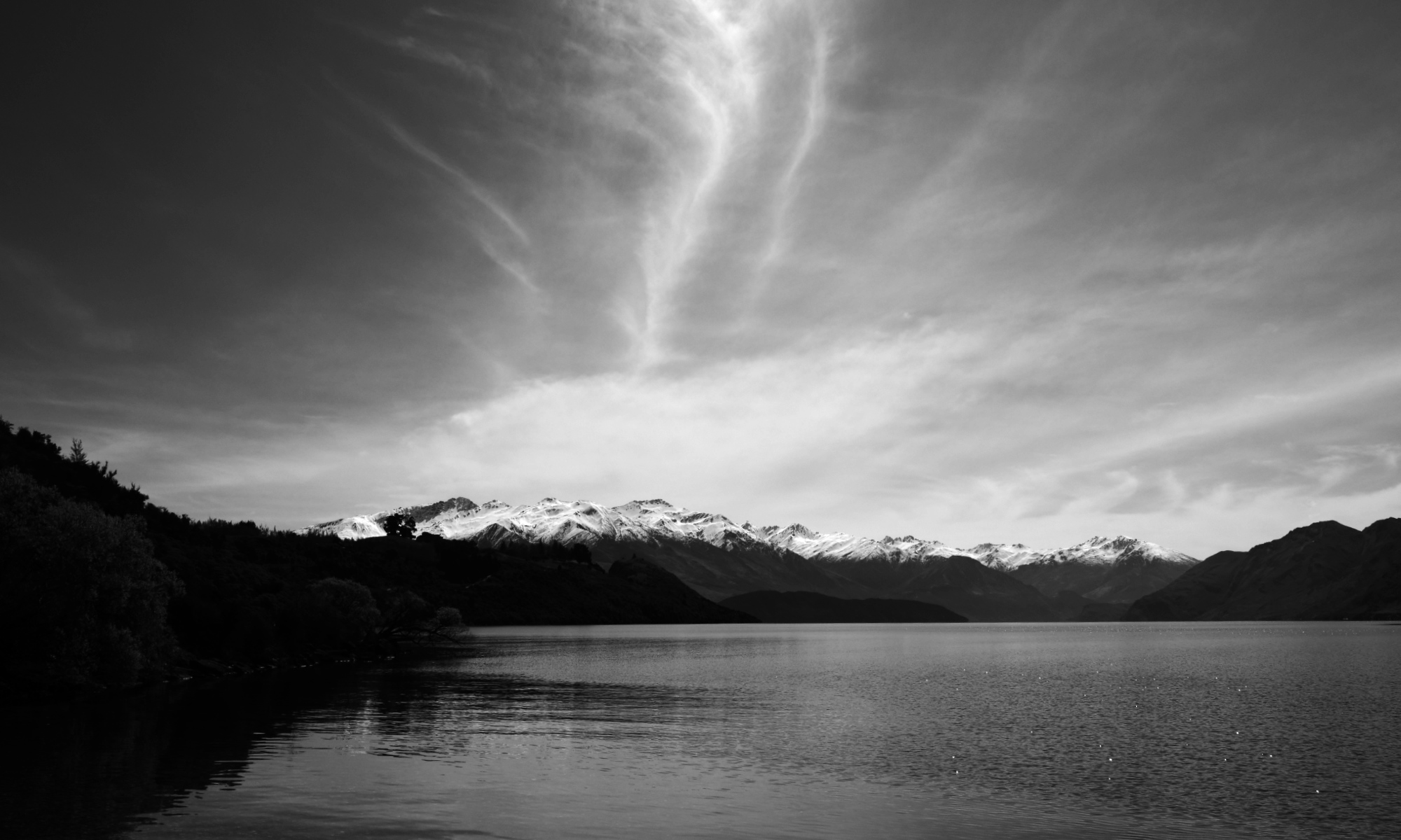
The Buchanan Mountains from Roys Bay, Lake Wanaka, New Zealand.
A similar view in black and white.
Black Peak in the center is often mistaken for Mt Aspiring.
Pastel sunset glow on Lake Wanaka.
Lake Wanaka’s Roys Bay in the evening. With Black Peak in the distance.
Lake Wanaka from Beacon Point.
Beacon Point is simply a very large and shallow area on Lake Wanaka’s shore. There is a permanent red light hundreds of meters from the point to warn boaties.
Glendhu Bay, Lake Wanaka.
Glendhu Bay is a short drive west from Wānaka, Otago, New Zealand. It is on the road to Treble Cone ski field and Mount Aspiring National Park. The bay has a motor camp that is popular with New Zealand locals over the New Year holiday period. Patronage numbers in the many thousands.
New Zealand landscape. They will often reach a height of 12-20 metres. Very popular in Britain, Europe, and the U.S. In the former they’re known as Torquay palm.
The flowers are very scented in early summer, and turn into bluish-white berries that birds love to eat. It is very fire-resistant. Māori used cabbage trees as a food, fibre and medicine. The leaves were woven into baskets, sandals, rope, rain capes and other items and were also made into tea to cure diarrhoea and dysentery. Lastly they were also planted to mark trails, boundaries, urupā (cemeteries) and births, since they are generally long-lived.
There are two identified species of flax in New Zealand – common flax (harakeke) and mountain flax (wharariki). (Harakeke is really a lily).They are unique to New Zealand and is one of our most ancient plant species. It grows up to 3 metres and its flower stalks can reach up to 4 metres. Tui, bellbirds/ korimako, saddlebacks/tīeke, short tailed bats/pekapeka, geckos and several types of insects enjoy nectar from the flax flower.
Flax was a valuable resource to Europeans during the 19th century because of its strength. It was New Zealand’s biggest export by far until wool and frozen mutton took over. Today, it is used in soaps, hand creams, shampoos and a range of other cosmetics. Flaxseed oil can also be found for sale.
Flax was the most important fibre plant to Māori in New Zealand. Each pā or marae typically had a ‘pā harakeke’, or flax plantation. Different varieties were specially grown for their strength, softness, colour and fibre content.
The uses of the flax fibre were numerous and varied. Weaving is now very common. Clothing, mats, plates, baskets, ropes, bird snares, lashings, fishing lines and nets were all made from flax leaves. Floats or rafts were made out of bundles of dried flower stalks. The abundant nectar from flax flowers was used to sweeten food and beverages. Flax also had many medicinal uses.
The outer layer represented the grandparents, whereas the inner layer of new shoots – the child – remained and were to be protected by the next inner layer of leaves, the parents.
Infrared of poplar trees
Poplars were first grown in New Zealand in the 1830s. Although ornamental in Central Otago they were primarily planted upwind in rather mundane straight lines to provide shelter for stock and houses. Especially from wind, but also to provide shelter from the intense summer sun .
This is probably the Lombardy poplar, given its column-like form. And was also often planted to mark boundaries and river fords as they could be seen from a distance. This planting is very grouped thus supplying quite a magical feel, in the gathering dusk of a summer evening.
That Wanaka Tree!
A willow that was once a fence post. Now a “must see/photograph” for every tourist that comes to New Zealand.
There were various reasons for lots of local NZ travel in 2019, and fortunately I had the time often to not rush trips across the likes of Central Otago, e.g. Wanaka to Dunedin and return.
The images below are very roughly in chronological order, but being lots of them I’ve uploaded with speed in mind – life in 2020 is nice and full, and sitting at a keyboard is best kept to a minimum. Enjoy!
Silver Peaks range behind Dunedin on a day tramp in the damp, which helps engender a sense of mysteryOn various days I’d help an old friend Wayne survey road upgrades in Southland, and so I got to see lots more of rural NZ than I knew existed, as usually the surfaces that needed to be marked out for upgrades were on anything but main roads.
These were long days with lots of water needed to keep hydrated.An evening on Cook Strait heading to Wellington on a roadie with an old and dear friend. This is looking back at the South Island
Wellington harbour
A relocated railway station in Central Otago now serving as a musterer’s farming hut. Bordering the Oteake Conservation AreaLan Yuan, Dunedin Chinese Garden, in Dunedin. The garden commemorates the contribution of Chinese people to the history and culture of the city.
I met my cousin and husband down there so it was a delightful family outing looking at some strong history, with them both and my sonA side trip and camp out in my Land Cruiser camper, to altitude on the Rock and Pillar Range – the last of the block mountains between the Cardrona Valley, Wanaka and Dunedin. A very windy area.Luxury with a cold beer out of the vehicle fridge, on the Rock and Pillar Range watching the sunset.
It got very windy in the wee hours though, and despite turning the truck around so it faced into the wind, to get a good sleep I drove a few km and parked up in a gully out of it, and woke to heavy rain.And when needing a bathroomAnother evening camp out – this time at old gold diggings on the Hawkdun Range, Oteake Conservation Area.
I’d climbed up to here in very cold winds to get some photos, and then descended in the dark back to my welcome little mountain hut on wheels, aka Cafe Toyota.
Mt Aspiring in the backgroundLower Rock and Pillar Range – Butterfly country once experienced and now imaginedMy new awning on the camper – should have made one years ago for the simple reason that in rain the end of the bed would get wet.
Note no poles and my 100 year old industrial sewing machine got an airingSunset from the Hawkduns.
Just myself, my three legged tripod and some nearby cattle to enjoy a perfect evening while on my way to DunedinThe now empty Cadburys chocolate factory in Dunedin.
Site of a new hospital coming up.During the year I finished off a new tire related web site in Wanaka, and so was delighted one day to spot this beauty outside the new buildingBest image from a sunset photoshoot at Glendhu Bay, WanakaUniversity of Otago where my son has studied for several years. A truly beautiful campusI had to visit Christchurch a few times during the year and since I’d never seen the city post earthquake I predictably ended up visiting the Cathedral ruins in the SquareChristchurch public toilets near the Square at nightChristchurch Public Art GalleryHistoric gold reserve at Macraes OtagoLuna Light Festival fairies – midwinter, Queenstown
The smog of winter in the Manuherikia River Valley, Central Otago
Mt Tutoko, Fiordland National Park – photo from the jet service into Queenstown from CHCWintery tarn and Hawkdun Mountains, Oteake Conservation Park, on the edge of the ManiototoThe front runners at the annual World Loppet Merino Muster race, the Snow Farm, Cardrona Valley, Wanaka.
These world class athletes on cross country skis are well into their 42 km race, and typically average speeds of up to 22kph over that distanceDuring the year I was appointed onto the Otago Conservation Board where we represent the public and advise the Dept of Conservation on select matters and strategic decision making.
As such I get to do field trips, and here is a native kaka at Orokonui Sanctuary near Dunedin.My son and girlfriend near the mouth of the Catlins River, Coastal Otago.
I had a large print done for him of this image as a Christmas present, and it was well received.
Yet another visit to a certain tree in the Nevis Valley – it’s my photo nemesis I think: satisfaction eludes me capturing the cold emotion of this old historic gold dredging pond, but I’m getting closer.
This visit represented the coldest I’d been in 2019.
Nevis Valley gold miners cottageLake Hawea from a day trip up Isthmus PeakOtago Conservation Board field trip Matukituki Valley – me on the rightProposed conservation land on Glenaray Station Otago/Southland. An inspection visit by helicopter pre submission.
One huge area – one hour flying only covered a fifth of the farm.Lake Wanaka flood Dec 2019.
Last event 1999, and thankfully this one stopped short of the shops, just!My favourite capture for the year – there I was all set up at Glendhu Bay for a more sedate shot and a jet ski came by causing some ripples I did not think I’d benefit from, however they made for something much better.Wishing you all the very best for you and yours for 2020 – may you always have time to smell the roses
One of the goals of Photo Quest NZ is draw attention to our unique New Zealand landscape in such a way as to do something tangible towards not only protecting it, but ensuring people grasp the need for habitat restoration for our native species.
NZ tomtit
Along the way though we leave footprints – not so much in the way of the obvious nasty chemicals used to make images pre digital, but in more subtle and insidious ways such as the need for electronics (with planned obsolescence, not to mention packaging), batteries and data storage.
With these thoughts in mind, and already being off the grid (all Photo Quest studio work is done via solar power) with equipment chosen for it’s potential longevity (can you believe a ten year old iPhone) thoughts recently have gravitated towards travel – the simple act of getting to remote locations and back again.
At least I have accomodation with me
It’s been a habit in the past to go to a new locations, take a few images and then retreat back to the office where they’re evaluated pending another trip to said location. The thought being to be there for sunsets and sunrises, or a snow storm or two.
However recently good friends invited me to have a day trip up Isthmus Peak – a viewpoint popular with young back packers, which gives great panorama views of both Lakes Wanaka and Hawea.
View from the lower section of the Isthmus Peak trackMts Castor and Pollux from near the top of Isthmus PeakLake Hawea on the left, Wanaka on the right, from near the top of Isthmus PeakLake Hawea on the left, Wanaka on the rightNear the topLooking across Lake Wanaka we could see the Wilken Valley peaks such as Mount Aeolus, but unfortunately the noon light did not make for a photo equal to the majesty of this view
On seeing the panoramas offered by this walk, it can come to mind to return for the golden hour after the sun has set, or better yet in this case, be there for dawn. Which actually means burning more fuel.
So one way to improve the light photographically is to use post production software, thus getting a competent image on one visit which goes someway towards sustainable photography. The dull image immediately above was the basis for this one
None of these blog page images are listed in our shop. Nor are they likely to be. But if you’re interested in purchasing, please note which image and email Donald so I can advise you with a price and options.
I’ve been around this now famous tree in more ways than one, e.g. swimming, and simply took it for granted for a few decades.
In snow, flood, or times of drought this tree that used to be a fence post earlier than 1939, endures with a determination to not just live, but to be a rock star of the Internet
However before it became famous a few of us had been there with cameras in sunshine and storm, simply because it was nice subject matter for landscape photographers.
But even then we had no idea how social media would change all that – now days getting an image of it with no people is the ultimate challenge.
And so the photographers came! With tripods, umbrellas, children and iPhones!
And often the sun sets on a perfect day, which finds the lake levels either up or down or somewhere in between
But what intrigues me of late is the tree seems to sense the attention it gets and becomes alive in another universe
Then again it is not always the centre of attention
If you happen to be interested in purchasing please note which image and email Donald so he can process the various options, and advise you with a link when completed
Last night a friend of mine from Oamaru [and ex Wanaka], Eion Shanks opened an exhibition of his paintings at Rippon Vineyard last night.
As well as owning a couple of his earlier works, which I really enjoy, I saw a few of the below at the Forester Galley in Oamaru back in March and thought it’d be nice to share them here.
One of the delights of a visit to the vineyard is the stunning view of Lake Wanaka, the rows of vines, and Ruby Island…
The entry door to Rippon Vineyard’s tasting building, which is also a popular venue for numerous events…
The tasting room main area…
Some of Eion’s work…
There are also some landscape style works at the exhibition, but due to lighting and composition being compromised by people enjoying them, they’re not featured here.
After a noisy few days in Wanaka over Easter weekend with vintage aircraft from the Warbirds over Wanaka Airshow filling the sky, I took a peaceful walk downtown in the early night.
The iconic White House Restaurant…
Many older cars were in town – many on display at the Airshow…
The town centre with my back to Lake Wanaka…
The town centre night life from the banks of Bullock Creek…
Wanaka by night – Looking along Tenby or Upton St from the war memorial…
Entry way to the iconic White House Restaurant near the New World supermarket
For the last few weekends in Wanaka it has rained. Since this is not the usual state affairs it can pose a few challenges when visitors come visiting.
I’ve long promoted Puzzling World as a fun place to go, but never thought of the National Transport and Toy Museum at the airport, and in this later case Brian led the charge – neither of us having any idea how much it has grown.
Brian found a car the same as his first back in his youth…
Vladimir, originally from Russia enjoyed seeing a Gaz from his home country…
I found an Austin, same model as my parent’s first car. It was more of indigo colour. Like this car it had very thoughtful footrests for passengers in the rear…
Then we adjourned to Puzzling World, where we were content to not be puzzled, favouring a more passive role playing with puzzles over a coffee…
I went out a couple of evenings ago to capitalise on the beautiful evening light we’ve been getting lately, and the cool airs, after another scorcher in Wanaka – I even had a swim 🙂
I was not disappointed with the burnt off grass tones, and the reflective nature of the water surface mimicking the clouds was a bonus …
As tourists when we tick the boxes on the must-visit places it can be a bit of a rush. Then it’s easy to overlook other rushes accommodated by the past.
Close to Wanaka and on the very busy road beside Lake Hawea that goes to Haast and South Westland it’s easy to rush by a little creek on the left called Craigburn, and it’s accompanying Dept of Conservation interpretation board, which alerts us to some history of gold mining endeavours upstream back around 1880, mainly in a tributary called Long Gully.
Now days called the Matatiaho Conservation Area it once sported 200 miners, three stores and a butchery, but this development was not long lived as the hope of finding the source of the gold in the very rugged and deeply incised headwaters upstream came to nought. Sadly little evidence of this has survived.
Flowering kanuka and lupins as seen from the DOC track, with a backdrop of Lake Hawea…
About an hour in, the track comes to an end as it drops into seclusion down by the river at some signage, and a small gate in a deer fence…
Hunters [permit required] usually frequent the rugged country further to the west [through above mentioned small gate], and to the much steeper southern areas including Mt Burke…
A couple of evenings ago a soft cold rain seemed set in, but then a few light patches appeared to support a rainbow in the north, so I rushed off to face that direction.
Meanwhile the clearance continued and looking west; well I followed my eyes.
On arrival near the famous Wanaka lake tree another excited photographer, who was rushing about, shouted out as he pointed, “is that the lonely tree?’
I gave him a thumbs up and off we scurried.
After getting this image on the fly, I lent him my tripod which seemed to surprise him – maybe they don’t do that sort of thing in Hong Kong!