I often go to Dunedin for many varied reasons, and one of the delights of every trip is a visit or two to the oldest botanical garden in New Zealand, which was established in 1863.
There are two parts of the Dunedin Botanic Garden, linked indiscernibly, known as the upper gardens and the lower gardens which merge nicely with the University of Otago campus. View Google Map
The initial garden was established on a site now occupied by the University but due to extensive flooding in 1868, the gardens were moved to their current site in 1869.
A rhododendron typical of the more naturalistic upper garden, where there is an arboretum, rhododendron dell, native plant and geographic collections.There are over 6,800 plant speciesIt covers 28 hectares of hillside and flat land to the north of the cityThe Garden is a preferred location for serious botanical studies as it is home to a significant number of plant collections In July 2010, the Dunedin Botanic Garden was awarded a rank of “Garden of International Significance” by the New Zealand Gardens Trust thus becoming one of only five gardens nationwide to be bestowed with this honour.The resources dedicated to the Gardens are significant, yet unlike many similar gardens in large cities overseas such as in Vancouver, entry to the Dunedin Botanic Gardens is freeThe roof of the Winter Garden Glasshouse – open 10am to 4pm, with nearby alpine house and toilets 9am to 4pm, and the cafe 9.30am to 4.30pmEach University year Dunedin city hosts 40,000 plus students and with the Gardens in close proximity scenes like this are common place. In short they offer an immense and peaceful place for relaxation and study, while also providing pathways to North Dunedin where there are lots of student accomodation flatsPeter Pan and is that Wendy whispering in his ear?A feature of the flat lower GardenFantails often frequent the Dunedin Botanic GardensSouth African section of the upper GardensThe formal rose garden and camellia collection in the lower GardensMagnolia in the upper Gardens
One of the goals of Photo Quest NZ is draw attention to our unique New Zealand landscape in such a way as to do something tangible towards not only protecting it, but ensuring people grasp the need for habitat restoration for our native species.
NZ tomtit
Along the way though we leave footprints – not so much in the way of the obvious nasty chemicals used to make images pre digital, but in more subtle and insidious ways such as the need for electronics (with planned obsolescence, not to mention packaging), batteries and data storage.
With these thoughts in mind, and already being off the grid (all Photo Quest studio work is done via solar power) with equipment chosen for it’s potential longevity (can you believe a ten year old iPhone) thoughts recently have gravitated towards travel – the simple act of getting to remote locations and back again.
At least I have accomodation with me
It’s been a habit in the past to go to a new locations, take a few images and then retreat back to the office where they’re evaluated pending another trip to said location. The thought being to be there for sunsets and sunrises, or a snow storm or two.
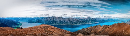
However recently good friends invited me to have a day trip up Isthmus Peak – a viewpoint popular with young back packers, which gives great panorama views of both Lakes Wanaka and Hawea.
View from the lower section of the Isthmus Peak trackMts Castor and Pollux from near the top of Isthmus PeakLake Hawea on the left, Wanaka on the right, from near the top of Isthmus PeakLake Hawea on the left, Wanaka on the rightNear the topLooking across Lake Wanaka we could see the Wilken Valley peaks such as Mount Aeolus, but unfortunately the noon light did not make for a photo equal to the majesty of this view
On seeing the panoramas offered by this walk, it can come to mind to return for the golden hour after the sun has set, or better yet in this case, be there for dawn. Which actually means burning more fuel.
So one way to improve the light photographically is to use post production software, thus getting a competent image on one visit which goes someway towards sustainable photography. The dull image immediately above was the basis for this one
None of these blog page images are listed in our shop. Nor are they likely to be. But if you’re interested in purchasing, please note which image and email Donald so I can advise you with a price and options.
I’ve been around this now famous tree in more ways than one, e.g. swimming, and simply took it for granted for a few decades.
In snow, flood, or times of drought this tree that used to be a fence post earlier than 1939, endures with a determination to not just live, but to be a rock star of the Internet
However before it became famous a few of us had been there with cameras in sunshine and storm, simply because it was nice subject matter for landscape photographers.
But even then we had no idea how social media would change all that – now days getting an image of it with no people is the ultimate challenge.
And so the photographers came! With tripods, umbrellas, children and iPhones!
And often the sun sets on a perfect day, which finds the lake levels either up or down or somewhere in between
But what intrigues me of late is the tree seems to sense the attention it gets and becomes alive in another universe
Then again it is not always the centre of attention
If you happen to be interested in purchasing please note which image and email Donald so he can process the various options, and advise you with a link when completed
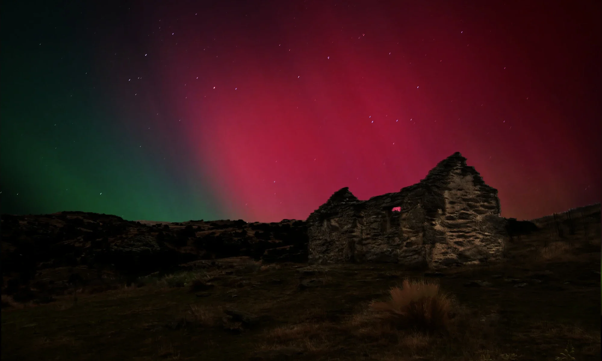
I’ve often wondered how this area got it’s name because to me it’s all about wind up on the tops, but then again I’ve not yet seen it’s full extent, especially the northern end around the historic [skiing] Big Hut area.
Recently though I’ve been poking my nose into the southern end, and it’s been enjoyable, despite being chased away by wind recently at about 3am – even after being parked into the gale the noise and rocking made sleep impossible, but that’s another story.
The ascent up from Styx Creek – I call this beautiful place Butterfly Rock…
This is another much larger tor higher up – a bit too high for butterflies
The view to the south…
The view to the north…
I used my 4wd Land Cruiser camper to get up aways to these high spots [google satellite map link], but on encountering a boggy patch and being alone I parked up and climbed on foot up to the left of this very large outcrop, then circled it and came down on the right. It was pretty chilly, so I “called it a day”, and descended, then spent sometime looking for a flat camping spot near where I’d parked, but everything was too steep, so I drove down to my favourite place…
A well earned cold beer and a sunset…
This used to be the Great Moss Swamp, but it was dammed for irrigation in the early 1980’s. Quite a tragedy by today’s reckoning, as it was the largest alpine wetland in the southern hemisphere. Now it’s called the Loganburn Reservoir…
My favourite camping spot at 1006 m above worry level – I call this spot yogi butterfly rock. But don’t be fooled – this is where the wind can be wild and free…
Dawn…
I “found” this a bit by accident while exploring the reservoir’s dam – they’re very private and even sheltered, but you’d best hurry if it’s raining! The crib, or bach as they’re known here is for those prone to fishing for introduced brown trout. The question is posed though: Ladies, gents and ? …
The rocks in the area were used as fence posts in the early days…
This photo was made on my last trip 2-3 weeks ago. The evening started out quite nice, but the ominous clouds heralded some very strong winds, and arrived at 3am, forcing me to move to a more sheltered location 7 km away…
Again from 2-3 weeks ago – the road heading north.. Many of the black and white photos above were made on the high point in the distance…
During some moments in time, recent time that is – less years in fact than can be counted on one hand alone, Queenstown Botanic Gardens changes in ways that only manifest on a few early winter nights each June.
With the onset of a dusk, hand-in-hand with sub zero temperatures, thousands of people can be seen walking the icy paths to the public gardens in a corner of Queenstown Bay.
There among the trees and ice covered waters magic unfolds as children and adults alike enter a realm where lights float and dance in and on the reflections of ice covered waters – places where minds come alight with imagination.
The by now beguiled wanderers will often be prone to stumbling bought on by magic imbalances, and the spells of wandering fairies.
And for every score of steps stumbled or walked, another “experience” comes to light.
Deeper in the forest it becomes even more immersive – lights climb trees, reflections dance on the forest floor like bright leaves in an autumn wind – a wind that carries beguiling music to which the lights dance.
Last night a friend of mine from Oamaru [and ex Wanaka], Eion Shanks opened an exhibition of his paintings at Rippon Vineyard last night.
As well as owning a couple of his earlier works, which I really enjoy, I saw a few of the below at the Forester Galley in Oamaru back in March and thought it’d be nice to share them here.
One of the delights of a visit to the vineyard is the stunning view of Lake Wanaka, the rows of vines, and Ruby Island…
The entry door to Rippon Vineyard’s tasting building, which is also a popular venue for numerous events…
The tasting room main area…
Some of Eion’s work…
There are also some landscape style works at the exhibition, but due to lighting and composition being compromised by people enjoying them, they’re not featured here.
After a noisy few days in Wanaka over Easter weekend with vintage aircraft from the Warbirds over Wanaka Airshow filling the sky, I took a peaceful walk downtown in the early night.
The iconic White House Restaurant…
Many older cars were in town – many on display at the Airshow…
The town centre with my back to Lake Wanaka…
The town centre night life from the banks of Bullock Creek…
Wanaka by night – Looking along Tenby or Upton St from the war memorial…
Entry way to the iconic White House Restaurant near the New World supermarket
There are countless references all over the Internet to this old area of Cromwell, Central Otago, so I won’t duplicate describing what it is all about, except to say that most of the old buildings, and sites of, were submerged when Lake Dunstan was filled. The buildings below, above the lake water level, then became the basis of an historic precinct, much visited by tourists and also host to a regular Sunday Market.
This cafe was closed when the photo was made, but they do make a great coffee, and give great service. To the right is the ever popular art cooperative, Hullabaloo Art Space. To the left is an ally way leading to the Marie Velenski’s little craft and art shop, which is the focus of the next few photos below…
The ally way...
Marie Velenski’s craft shop…
Marie, with some of her art work…
A colourful quince tree that Marie takes care of…
The view in the other direction from Marie’s doorway. On the taking of this image by-the-way, I did not see the slight female figure in the doorway. It is probably not a ghost, but I find it disconcerting that it showed up, for me at image processing time…
Nearby there is a blacksmith building that has been recreated…
Lastly, a nice wall I discovered nearby, quite close to a derelict building which is the subject of the featured image above…
For the last few weekends in Wanaka it has rained. Since this is not the usual state affairs it can pose a few challenges when visitors come visiting.
I’ve long promoted Puzzling World as a fun place to go, but never thought of the National Transport and Toy Museum at the airport, and in this later case Brian led the charge – neither of us having any idea how much it has grown.
Brian found a car the same as his first back in his youth…
Vladimir, originally from Russia enjoyed seeing a Gaz from his home country…
I found an Austin, same model as my parent’s first car. It was more of indigo colour. Like this car it had very thoughtful footrests for passengers in the rear…
Then we adjourned to Puzzling World, where we were content to not be puzzled, favouring a more passive role playing with puzzles over a coffee…
I occasionally come across philosophical discussions about the ethics of using post production software on an image.
Working with this one, and nursing a sense of vexation at the challenges last night, I got to thinking of the different ways this sort of discussion can go. Here are my thoughts on this:
I’m in a helicopter with a young pilot I don’t know, flying across Fiordland N.Z. in snow flurries that saw us “winging it” near landforms for the sake of navigation, and frankly I’m lost to the myriad of ridges and valleys sprinkled by snowflakes and veiled by clouds being prised apart by a sun rising on the back of a weather front.
Then it happens again, like usual: I “see” a picture waiting to be made, and raise my lens to align with the spot of highest clarity, dubious in the misted perspex window that comprises half a door.
I get home OK and later examine the image looking for what I felt at that moment, and there are none. But I know those feelings are in the file somewhere!
This is the second attempt to extract how I felt, and nothing else. In short I don’t care about ethics – just how to frame it all to fit the sense of mystery that floated past me.
You see Fiordland, for all it’s beauty, “takes no prisoners”, but it embodies part of my heart!
Spit Island, Fiordland NZ
Fiordland New Zealand ~ Dusky Sound
Spring snow on the mountains alongside Fiordland’s Long Sound, New Zealand
I went out a couple of evenings ago to capitalise on the beautiful evening light we’ve been getting lately, and the cool airs, after another scorcher in Wanaka – I even had a swim 🙂
I was not disappointed with the burnt off grass tones, and the reflective nature of the water surface mimicking the clouds was a bonus …
This area of New Zealand’s remote and rugged South Westland is truly worthy of World Heritage status bestowed sometime ago by UNESCO. It extends south from the Cook River to Fiordland and encompasses the Franz and Fox Glaciers – 2.6 million-hectares in total.
One of the benefits of living in the Wanaka area is it is very close to this amazingly diverse landscape, and this selection is from a quick trip to the Jackson and Cascade rivers area in Nov. 2017
When gold was discovered in Bannockburn near Cromwell in 1862 it was not soon before enterprising miners climbed higher up the Carrick Range behind the alluvial workings, to look for the quartz reefs that fed the terraces below, that are now sluiced away.
By 1876, based on good returns and the knowledge that more water would soon be available to drive the stampers by waterwheel, there were soon five batteries in these higher areas. However the reef then petered out gradually and mining had ceased by 1898.
The restored wheel, the second largest in the Southern Hemisphere apparently [the largest being the Old Mill Wheel in Oamaru], now stands alone, as the stamper battery it was driving was moved across the valley, where it still sits today reasonably well preserved, and relatively difficult of access.
Clever use by the miners of long ago of an existing rock…
Lake Dunstan and Cromwell from the saddle above the gully where the waterwheel sits...
Looking back at the crest of the Carrick Range. A 4wd road from Duffers Saddle on the left, can just be seen…
The water race that turned the waterwheel is still in use today for irrigation. The damaged fluming in this photo once directed water from it down the steep Adams Gully to the right where there are remains of the 5 stamper battery as mentioned above…
The Adams Gully stamper and gold processing plant remains. Note the fluming as mentioned above, up the gully…
To access the waterwheel: there are quite a few web sites hosted by various organisations that list directions – just Google “Carrick Range waterwheel”. Most of them list two ways: climb up from Bannockburn on foot, bike or 4wd, or drive to the top of nearby Duffers Saddle and then walk, bike or 4wd along and down to the site. The former I’d not recommend, and it’s certainly not a track for a soft 4wd such as a Subaru or Rav
The largest waterwheel in the Southern Hemisphere, the Old Mill Wheel in Oamaru under restoration as of Oct. 2017. This wheel weighs in at 50 ton, which would probably make the Young Australian about 35…