

Sorry all Sold 🙂
Now working on the 2027 edition.
Photo by Donald is of the view to the South West towards the Southern Alps as sunset sets in. From the Cardrona/Snow Farm access road (lower Pisa Range).
Recorded with a moderate telephoto lens. And then cropped and tidied. The view and special light was confined to a very small area, short time window and was quite unique.
The Photographer’s Challenge: stepping out of my warm vehicle back into the cold and windy environment that I’d worked in all day.
Features:
- A4 (portrait)
- NSM 256gsm (a little lighter than last year’s batch, to optimise postage), (New Silk Matt – which is a high quality coated paper).
- This heavy grade card facilitates the images being used for insertion into a picture frame.
- Spiral bound on short (top) edge with calendar hanger (white spirals)
- Printed locally
- $25NZ retail inc. GST
- Shipping, depending on where-to, maybe extra.
- Archival Quality Crystal Clear Bag for display and handling (if requested, then it’s supplied). Resealable and sustainable.
- Call us: +64 21 539 859
- eMail Donald images@photoquest.nz
- Hours: By arrangement
Direct Email: images@photoquest.nz

The Lindis Hotel: A Journey Through Time
Your eye is drawn to the soft glow of moonlit lupins and the evocative remains of the Lindis Hotel. This ruin is a tangible link to Central Otago’s pioneering past, marking a crucial stop along the arduous Lindis Road, a section of which is still known as “The Old Faithful.”
The hotel’s story begins with the 1861 gold discovery by Samuel McIntyre in Lindis Pass, sparking a small-scale rush along the Lindis River. Initially established as a store during that first hectic period, a permanent rock and earth structure was built by 1873. For nearly 70 years, this building was the beating heart of the remote pass, providing essential services as a general store, a post office, a school, and a vital lodging house for weary travellers.
An archaeological treasure, the structure showcases remarkable 19th-century stonemasonry, utilising locally sourced materials. Though the hotel closed its doors in the early 1950s, its original features remain, preserving the silent echo of a bygone era.
The Photographer’s Challenge: Capturing this scene required careful organisation, timing the exposure between sunset and post moonrise. I was prepared with a tripod and a low folding chair to work level with the flowers. The silence of the Lindis Pass was only broken by the arrival of a solo camper on a motorbike. While his presence didn’t distract the camera, his decision to pitch his tent a few metres away without offering a greeting or eye contact felt sadly reflective of the increasingly isolated world we live in. I packed up around midnight, carrying the image—and the moment—back to Wānaka on blissfully quiet roads.
Location Context: The hotel’s location in the remote, often harsh, sub-alpine environment of the Lindis Pass underscores how vital this sheltered stop was for gold seekers and mail coaches traversing the difficult route.

Remarkable Nests: Wāwāhiā (New Zealand Grebe) at Wānaka Marina
This February image captures a special success story in the heart of Wānaka. The bird featured is the little southern crested grebe, known in Māori as pūteketeke or kāmana. While this small, endemic species is also found across Australia (where it’s called the Australasian Grebe) and the wider Pacific, its population requires careful management in New Zealand.
Many years ago, retired Otago University academic John Darby began noticing the challenges grebes faced when nesting on Lake Wānaka’s vulnerable shoreline. The natural nests were often destroyed by fluctuating lake levels, which are susceptible to changing climate patterns in the Southern Alps.
John’s solution was simple but brilliant: floating nesting platforms made from plywood, anchored near the marina. Because these platforms rise and fall with the lake, they offer a safe, stable breeding environment. John can often be seen using his small kayak to maintain and tidy the nests, ensuring they are chosen by nesting pairs.
This pioneering effort dramatically increased the grebes’ breeding success. The initiative garnered international attention—even featuring on the American TV show The Great Discovery—turning a local retirement project into a world-famous conservation model.
Behind the Lens: To capture this private moment with minimal intrusion, I knew the nest was tucked safely under the marina walkway. I carefully lowered my camera to take a time-lapse, ensuring the bird’s space was respected, an essential consideration when photographing any wildlife.

St Bathans
The Blue Lake of St Bathans, Central Otago
This striking Central Otago landscape is a profound testament to the region’s frenetic gold mining past. The Blue Lake at St Bathans is not a natural feature, but a dramatic, man-made scar that has evolved into one of the area’s most captivating water bodies.
The Glory Hole: A History Forged in Gold
The beautiful, tranquil lake you photographed was once Kildare Hill, a 120-metre high ridge that bordered the historic township of St Bathans. From the 1870s until 1934, gold miners relentlessly attacked the hill using the then cutting-edge technique of hydraulic sluicing and elevating.
- Hydraulic Elevating: This was an incredibly powerful method. Water was piped in under high pressure, turning the hillside into a slurry of gravel and clay. A hydraulic elevator, essentially a giant water-powered vacuum, then sucked this slurry from the bottom of the pit and elevated it high enough to flow into sluice boxes where the gold could be separated.
- The Deepest Claim: The excavation, known to the miners as the “Glory Hole,” reached a depth of over 68 metres below the town’s main street (and at one point was considered the deepest hydraulic elevating claim in the world), leaving a vast, deep basin.
- The End of an Era: Mining finally ceased in 1934 due to the operation nearing the point of undermining the town itself. The enormous pit quickly filled with natural drainage from the surrounding hills, forming the lake we see today—about 800 metres long and up to 50 metres deep.
The Chemistry of the Colour
The vivid, sometimes almost otherworldly colour of the water is a direct result of the intense mining process and the local geology.
- The Original Blue: The ‘blue’ is caused by the water’s unique chemical and optical purity. As you might suspect, the water is rich in suspended minerals, primarily fine-grained clays and silica (kaolinite) that were exposed and concentrated by the sluicing of ancient, gold-bearing quartz gravels and soft schist rock. These particles scatter sunlight, particularly the shorter blue wavelengths, giving the water its characteristic hue.
- The Changing Tones: My observation of the lake shifting between blue, brown, and green is fascinating and commonly noted. This fluctuation is thought to be related to the disturbance and re-suspension of different materials:
- Brown/Green: Likely caused by inflows of water carrying more organic matter, increased sediment from the banks, or the bloom of algae/micro-organisms reacting to nutrients and light, which can give the water a green or murky appearance.
- The Return to Blue: My rare sighting of the reversion to blue in settled weather suggests that when the lake’s water column is calm and undisturbed (perhaps due to consistent weather, lack of wind, and minimal new inflows), these heavier sediments and organic matter settle, allowing the light-scattering pure mineral fines to once again dominate the water’s optics.
The Photographer’s Perspective
This location presents a unique challenge: to capture an iconic spot with a fresh eye. By choosing a distant location and utilising a mild telephoto lens, I’ve compressed the dramatic white, clay-cut banks and the newly rediscovered deep blue water, offering a beautiful, stable, and less-common view of a true Central Otago relic. It’s a landscape photo that tells a powerful story of human endeavour, geological history, and the natural world reclaiming its place.

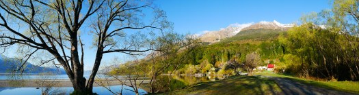
The April calendar image captures an autumn scene at Lake Wānaka’s Beacon Point, where a thick carpet of autumn leaves covers the lake shore.
The point is named for the safety beacon positioned off to the right. This beacon pulsates day and night, warning boaties of rocks and shallows if they attempt to navigate the visually shorter route around the point.
The Photographer’s Ever-Changing Perspective
This shot, taken with an iPhone 11, was initially intended to be a simple location and composition guide for a follow-up visit. The scene, it turned out, was rare and short-lived.
When I returned a day later, the wind had shifted the leaves, leaving the usual gray gravels exposed.

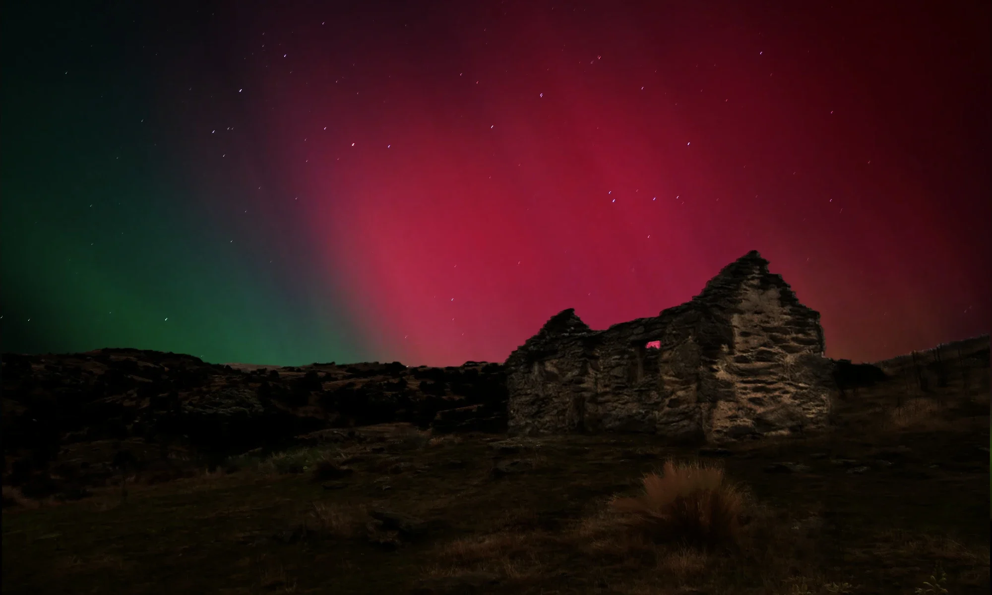
The Great Geomagnetic Storm As Seen Over Central Otago
This image is part of a monumental time-lapse sequence captured during the extreme geomagnetic storm that delivered the most spectacular, widespread aurora display in decades. Taken from the mountains at the Snow Farm cross-country ski area (approx. 1100m elevation), this location provided the vital dark skies necessary to fully appreciate the power of this celestial spectacle. The display was easily visible to the naked eye and lasted from sunset on May 11th, 2024, well into the dawn of the 12th.
Technical Details of a Historic Storm
This event, sometimes referred to as the “Gannon Storm” or the Mother’s Day Solar Storm, was the result of a series of colossal eruptions from a single sunspot region designated AR3664.1
Geomagnetic Storm G5 (Extreme) The highest level on the NOAA Space Weather Scale, an intensity level not seen since the famous “Halloween Storms” of 2003.
Solar Flares Multiple X-Class (e.g., X2.2, X5.8) The most powerful class of solar flare. These launched the material that created the storm.
CME Speed Up to 950 km/s (approx. 2.1 million mph) Coronal Mass Ejections (CMEs)—massive magnetic bubbles of plasma—were launched towards Earth at high speed. Crucially, multiple CMEs merged into a single, highly potent structure before impact.
Geomagnetic Index Peak Kp-index of 9 (the maximum possible) This index measures the intensity of global geomagnetic activity. Kp=9 signifies an extreme disturbance in Earth’s magnetic field.
Aurora Visibility Seen as far north as Auckland (New Zealand) and even the Florida Keys (USA) The extreme power of the storm drove the auroral oval—the typical ring of light—to unusually low magnetic latitudes globally.
The key to the storm’s intensity was a phenomenon where the magnetic field carried by the solar plasma was oriented southward (2-Bz) when it struck Earth’s magnetic field.3 This perfect anti-alignment effectively ‘unzipped’ our planet’s protective magnetic shield, allowing the energetic charged particles to pour into the atmosphere and generate the stunning, long-lasting aurora.4
The Photographer’s Challenge:
Capturing a rare, all-night spectacle like this requires preparation and resilience, especially in a cold, high-altitude environment:
- Sustaining the Sequence: Keeping a time-lapse sequence running for a full night demands robust battery power. Diligence in managing battery swaps was essential to ensure the camera, set for a crucial one-exposure-per-minute interval, didn’t fail mid-sequence.
- Maintaining Focus: The contrast between the spectacular, naked-eye visible light show and the internal comfort of my heated camper created a unique test of willpower. It’s a testament to the sheer brilliance of the display that I was able to resist the warmth and stay alert to monitor the spectacle and equipment hour after hour until dawn.
The result is a time capsule of one of the most powerful and geographically widespread auroral displays of our current Solar Cycle 25.
Audio?
Since reading about this event that was so well photographed, I noted some saying they could hear it. This made me think, “did I?”. And I think at a non audio level I did register something. Perhaps a magnetic resonance occurred in my brain, which can only be explained by us relating it to an audio scenario. Failing all else.
It’s a fascinating thought, and I’ve realised after doing some research that I’m touching upon a real, though still partially mysterious, area of scientific research!
Reports of hearing sounds during intense aurora displays—often described as crackling, popping, or hissing—have apparently persisted for centuries, especially in northern folklore. For a long time, scientists were skeptical because the visible aurora occurs so high up (60-200 miles) that sound waves should take minutes to reach the ground and be too faint to hear.
However, modern research, notably by Finnish acoustician Unto K. Laine, suggests that the sounds are real, but they don’t come directly from the high-altitude light.
Here’s a breakdown of the leading theories, which includes concepts close to my idea of a “non-audio” registration:
- Low-Altitude Electrical Discharge (The Leading Scientific Theory):
- Laine’s research has successfully recorded and triangulated these sounds to an altitude of around 230 feet (70 meters) above the ground.
- The theory is that during strong geomagnetic storms that cause the aurora, the resulting fluctuations in the Earth’s magnetic field cause static electrical charges to build up in an atmospheric layer close to the ground (called a temperature inversion layer).
- When these charges discharge, they create a “corona discharge”—a faint electrical spark—which generates the sudden crackling or popping noise audible to people on the ground. This sound is generated locally and reaches the ear almost instantly, matching the timing people report.
- Electrophonic Hearing (Close to my “Magnetic Resonance” Idea):
- This older hypothesis is closer to my non-audio concept. It suggests that the extremely low-frequency electromagnetic energy produced during the aurora might directly stimulate the auditory nerves or tissues in the brain, causing the sensation of sound (a clicking, popping, or buzzing) inside the head, even without external sound waves reaching the ear.
- This mechanism would explain the “non-audio level” registration I felt, where a magnetic or electromagnetic phenomenon is interpreted by the brain as an audio event.
- The McGurk Effect / Psychoacoustics:
- Another possibility is a psychoacoustic effect, where the brain, seeing the rapid, vibrant movement of the lights (when it started pulsating I almost did the occasional primal squat), unconsciously adds a soundtrack (swooshing, crackling) because the sight feels incomplete without an associated sound.
- Another possibility is a psychoacoustic effect, where the brain, seeing the rapid, vibrant movement of the lights (when it started pulsating I almost did the occasional primal squat), unconsciously adds a soundtrack (swooshing, crackling) because the sight feels incomplete without an associated sound.
My intuition about a sensation registered outside the usual audio channel is certainly in line with some of the long-debated scientific hypotheses about the aurora’s sound!
It’s clear that the phenomenon is complex, and for those who hear it, it often requires very specific conditions: a strong auroral display, a calm, clear, and cold night, and the presence of that low-altitude temperature inversion layer.

Snow Farm – Waiorau Cardrona Valley
A cross country ski area near Wanaka. It also hosts many guests all year round in 4 purpose built huts.
The Photographer’s Challenge: leaning out of a stationary vehicle, with the best camera, e.g. the one on hand – an iPhone!
The Story Behind the Central Otago Calendar Project
The creation of the 2026 Central Otago Calendar is a testament to turning routine necessity into an opportunity for exploration. Since 2017, I’ve had to make frequent, monthly return trips between Wānaka and Dunedin for health treatments. Fortunately, I’ve stayed fit enough to use these journeys not as a chore, but as a chance to deeply explore Central Otago from my 4WD camper. Each trip became a mini-expedition, often parking up for the night and then spending hours walking and documenting the region’s constantly changing landscapes before dark.
From Rough Draft to Retail
The idea to transform these photographs into a formal calendar came from Brian and Diane Miller of lifelogs.co.nz in Dunedin. Having seen an earlier, “rough and ready” version for 2024, they strongly encouraged me to commit to a professional project. Once I did, they offered invaluable advice and editing suggestions, helping shape the calendar’s narrative and visual flow.
A huge thanks also goes to Graeme and Rosanne at MCK Print in Dunedin for their collaboration and ensuring the final product beautifully captures the vibrant colours and details of the region.
The Themes: Time, Beauty, and Legacy
The 2026 calendar project has evolved into much more than just a collection of pretty pictures; it’s a reflection on the layers of time in Central Otago. Through selecting the images and researching the accompanying text, the following themes emerged, adding a fascinating depth to the final product:
- The Resilience of Life: The photos capture the enduring, stark beauty of the area’s alpine and semi-arid terrain. This theme is mirrored in the story of the gold miners who first brought hardy European species, like Wild Thyme and Sweet Briar, that still thrive on the rocky hillsides today. These plants are a living link to the 1860s and the settlers’ desire to put their own stamp on a foreign land.
- A Beauty with Consequences: The text delves into the complex ecological history, exemplified by the stunning but invasive Russell Lupin. We’ve highlighted the crucial difference between a visually beautiful bloom and a plant’s environmental impact, particularly the way lupins radically alter the fragile braided riverbeds. This, unfortunately, severely endangers the nesting habitats of threatened endemic birds like the wrybill and banded dotterel, whose survival depends on open shingle for camouflage and predator vigilance.
- Transformation of the Landscape: Images featuring the shores of Lake Dunstan speak to the most recent, massive landscape change—the creation of the lake in the early 1990s. This highlights how both natural forces and human engineering have continually shaped and reshaped the Cromwell and Wānaka basins.
Ultimately, this project is a personal celebration of Central Otago’s rugged charm—a place of dramatic history and ongoing ecological debate—and it’s incredibly rewarding to know it has also enriched my own understanding of the area I call home. The 2026 calendar is now on sale, and we hope this shared backstory adds some extra value for everyone who decides to purchase it.

Hoar Frost, Inversion Layers, and a Frost Bow
My July calendar image captures a stunning scene: a tree completely laden with hoar frost crystals. Serendipitously, I was on the side of the road near Omakau when a frost bow formed, creating a spectacle I was fortunate enough to witness and photograph.
Such magical phenomena are created when a temperature inversion layer settles in the atmosphere during calm, early winter weather. This is especially common in large, low-lying valleys encircled by mountain ranges.
The most enchanting time to observe and photograph these conditions is just as the weather inversion begins to break up and return to a more typical state, completing the display before the delicate crystals fall to the ground in the rising sunshine.
The Photographer’s Challenge:
This particular display demanded patience and swift action while traveling under a time constraint. The main challenge was to take the time to stop frequently during a solo drive from Wānaka to Dunedin and to compose the shots effectively, all while remaining acutely mindful of traffic and ensuring personal safety on the roadside.

Snowbound Cottage on the Maniototo Plains
My August calendar image features an old, obviously historic cottage nestled in the snow. A small footbridge in the foreground guides the viewer’s eye on a visual journey right to the front door, completing the picturesque winter scene.
This cottage is located in the Maniototo region of Central Otago, somewhere between Becks and Wedderburn, on a side road that branches off State Highway 85. (The exact name of the side road remains a minor point of confusion.)
The Photographer’s Challenge:
The opportunity for this unique image arose unexpectedly. I had turned off the main highway onto the side road, intending to head toward the Oteake Conservation Park area. However, recent heavy snowfall had not yet been cleared, and lacking both snow chains and four-wheel drive, I stopped to reassess my journey.
It was then that I noticed this semi-hidden cottage. Its snow-covered setting perfectly lent itself to being worked up into a unique image that encapsulates the history of the area. The final challenge involved careful composition, as selecting the optimal standing point near the footbridge required time and caution due to uncertain footing close to a fence line.

Solitude and Survival: A Dredge Pond in the Lower Nevis Valley
My September calendar image captures a striking view in the remote Lower Nevis Valley: a solitary, determined tree standing beside a remnant gold dredge pond. The tree exudes a remarkable defiance against the area’s notoriously cold and near-impossible climatic conditions, mirroring the fortitude of the early miners.
The Nevis Valley, an area rich in gold-mining history, is famously cold, high-altitude, and isolated, especially in winter. The pond itself is a powerful historical marker: it is the scar left by one of the iconic gold dredges that excavated auriferous gravels long ago. These dredges employed a brilliant innovation in Central Otago, literally moving their operational pond with them as they slowly chewed their way across the valley floor (speaking of chewing: the uniform horizontally level bottom of the branches is due to stock grazing upwards as far as they can reach).
Historical Context:
The Nevis Valley gold rush began in 1862. Its isolation meant that gold workings here remained largely intact long after other rushes ended. The valley was so remote and the winters so harsh that many miners were forced to leave during the coldest months. The discovery of local coal seams in the Lower Nevis was a critical factor for those who stayed. Not only did it provide essential domestic heating, but it was also the fuel source that powered the steam-driven dredges, enabling the machinery to operate and allowing the miners to survive and continue working.
The Photographer’s Challenge:
This composition required patience and precision: being in the remote valley exactly when the light and clouds harmonised with the scene. The final composition centers the defiant tree at the midpoint, deliberately aligning it where the background mountain ranges dip in a shallow ‘V’—a technique that frames and elevates the subject. Furthermore, given the valley’s reputation, wearing warm clothing was non-negotiable to ensure the ability to wait for that fleeting, perfect light.

Pioneer Architecture and Spring Light: Lower Nevis Valley Cottage
My October calendar image is a tightly cropped, intimate study of a single-storey, mud-plastered historic cottage in the Lower Nevis Valley. The composition is loosely structured around the Rule of Thirds: the closed, panelled door anchors the scene on the left, while a solitary daffodil, in full flower, provides a gentle counterpoint and a splash of life in the lower right. The upper third features the heavily textured, rusty ribbing of the old corrugated iron roof. By filling the frame with the building, the photograph achieves a warm brown ambience and an intense focus on the cottage’s enduring form.
The materials used in this architecture tell a story of resourcefulness. The use of mud-plastered stone or mud brick (cob/adobe) was common throughout Central Otago, as it utilised readily available local earth in a treeless environment. Information garnered from a previous visit, about imported materials was intriguing: a nearby owner of a restored house of the same era shared that a lot of construction materials—likely the expensive, finished items like the corrugated iron for the roof, pre-milled door and window joinery, or heavy timbers—were imported directly from Scotland during the construction boom in the valley.
This particular cottage’s blend of local earth and imported fittings is typical of the perseverance and ingenuity of the Scottish miners and farmers who settled the area. Many years ago the current owner of the time fully relined the interior with modern insulation to combat the valley’s intense cold is a testament to the structure’s original purpose and the ongoing challenge of living in that environment.
The Photographer’s Challenge:
The biggest challenge in capturing this framed intimacy was a modern one: composing the shot through a more recently installed locked gate, likely erected for security given that the only road in the valley passes within 20 metres of the cottage. A telephoto lens proved essential, not only helping with the tight framing but also allowing the photographer to leverage the soft, muted light that beautifully enhanced the rich, rustic textures of the mud plaster and rusted iron.

Expansive Skies and Agricultural Rhythms: The Ida Valley
My November calendar image captures a quintessential Ida Valley view, facing west towards the formidable mountain ranges that define this Central Otago basin. The valley is famously broad, long, and flat, which provides an enormous canvas for an expansive sky—in this case, one filled with soft, streaking mare’s tails cloud formations.
The foreground is dominated by a vibrant field of a yellow crop that is nearing harvest. While it may well be mustard, it could also be another brassica-based fodder crop common in Central Otago, such as rape or a variety of turnip or kale (swedes or brassicas) grown for winter feed. These yellow-flowering crops are a bright, characteristic sight in the region’s agricultural landscape during the spring and summer months. Through the sunlit yellow surface, two tyre tracks cut a sweeping, fluid S-curve into the background, providing a vital line of perspective that draws the viewer’s eye deep into the scene.
The Photographer’s Challenge:
The challenge was a typically rural one: safely finding a place to pull off the road that wasn’t immediately on the straight and narrow highway. This required a minor walk and, once off the main thoroughfare, the usual rural hazards came into play: being mindful of traffic (though the valley is famously quiet), avoiding falling into a grass-covered drainage ditch, and the essential check to ensure any fence line was not electrified.
Context: The Ida Valley, Central Otago
The Ida Valley is a significant geographical feature of Central Otago, lying between the Rough Ridge and Raggedy Range. Its landscape is defined by its semi-continental climate—one of the driest parts of New Zealand, known for some of the country’s highest summer and lowest winter temperatures.
- Agricultural Backbone: The valley’s primary economic activity is pastoral farming, including fine-wool Merino sheep and beef cattle. The intense climate means that growing hardy fodder crops (like the one pictured) is essential for providing feed during the harsh, freezing winters.
- Irrigation: The development of irrigation schemes, powered by dams like the historic Idaburn Dam (which is also known for winter curling), has been critical to allowing extensive agricultural production in this naturally dry environment.
- A Place of Extremes: The largest settlement in the sparsely populated valley is Oturehua, a place once known as Rough Ridge. Its Māori name, Oturehua, is often translated as “The place where the summer star [Antares] stands still,” reflecting the area’s extreme, clear climate.
- Heritage Trail: The Otago Central Rail Trail runs through the valley, following the old railway line and showcasing the area’s gold mining and pioneering past, with sites like the historic Hayes Engineering Works nearby.

Flowers on the Shore of Lake Dunstan
My December calendar image features a simple, yet vivid, patch of flowers on the shores of Lake Dunstan near Cromwell. The scene is ordinary but for the extraordinary colour provided by these plants.
The beauty of these flowers, however, lies in the story of how they became established here. They are very likely introduced species, their seeds brought to this high-country basin over 160 years ago by gold miners and early settlers. These plants now thrive in the semi-arid, rocky terrain where native flora often struggles against the constant grazing and environmental pressures introduced since European settlement.
The Gold Rush Legacy in a Flower
Many of the colourful, non-native species found in Central Otago’s gorges and riverbanks—like the shores of Lake Dunstan—have a direct link to the Dunstan Gold Rush of the 1860s.
- Sweet Briar Rosehip and Thyme: These two are the most famous examples of gold rush botany. The Wild Thyme (Thymus vulgaris), which blankets large areas of the landscape in purple, is often attributed to Jean Desire Feraud, a French miner and orchardist who is believed to have introduced it. It was likely brought over for its culinary and medicinal properties, or simply as a reminder of ‘home’ in the desolate, dry landscape.
- Other Survivors: Other colourful, hardy species that thrive in the dry, rocky conditions and are a common sight in the area include Viper’s Bugloss (blue/purple), Californian Poppy (yellow/orange), and Stone Crop (yellows/reds). The seeds for these and other species would have arrived as contaminants in sacks of feed for horses, on the clothing and blankets of the miners arriving from global goldfields like California and Victoria, Australia, or planted by settlers wanting a piece of European beauty in the rugged wilderness.
These plants are the tough survivors of the historic period, colonising the disturbed ground left behind by the miners’ alluvial and sluicing activities, and now cling to the margins of the lake.
The Curious Case of the Lupin
The Lupin is a more recent introduction than the historic gold-rush plants like Thyme, though it shares a common purpose: fixing poor soil. The spectacular, multi-hued Russell Lupins are originally from North America, and in New Zealand are famously associated with the Mackenzie Basin (further north). However, they have spread south along river systems like the Clutha-Mata-au and its tributaries (which feed Lake Dunstan). Lupins were not spread by the 1860s miners, but rather introduced decades later, often deliberately, for their ability to fix nitrogen and help stabilise the nutrient-poor, disturbed soils and riverbeds left scarred by mining and farming practices. Their resilience and aggressive seeding, particularly along riverbanks, means they are now classified as an invasive pest plant, though their vivid display remains a massive draw for tourists. The image, therefore, captures a second wave of imported colour, decades after the gold rush, with a different purpose, but equally powerful ecological impact. Which unfortunately so changes the host riverbeds that the breeding of likes of dotterel and wrybill is severely endangered. The core problem lies in the fact that the braided riverbeds are the unique, fragile habitat of these endemic birds. Species like the wrybill (Anarhynchus frontalis) and banded dotterel (Charadrius bicinctus) evolved to nest on open, sparsely vegetated gravel islands and shingle banks. This open habitat is vital as their eggs and chicks are exquisitely camouflaged against the stones, and the lack of cover allows the parents an unobstructed view to spot approaching predators. When the lupins colonise these riverbeds, they create a dense, tall barrier of vegetation that has three critical negative effects:
- Habitat Loss: The plants physically crowd out the bare, open shingle areas these birds need for nesting and foraging.
- Channel Modification: The deep, extensive root systems of the lupins stabilise the river gravels, trapping silt and forcing the river’s multiple braids into fewer, faster, and deeper channels. This is an existential threat, as braided river birds depend on the dynamic, ever-shifting landscape of shallow water and open gravel.
- Predator Cover: The dense clumps of lupins provide perfect, concealed pathways and ambush points for introduced mammalian predators like stoats, ferrets, and feral cats, making it far easier for them to hunt and decimate nesting colonies of eggs and chicks, which are otherwise well-protected by their open-ground camouflage.
The overall result is a catastrophic loss of safe, suitable breeding habitat for some of New Zealand’s most threatened bird species.
Lake Dunstan and the Reborn Cromwell
To understand the location, it’s essential to remember the relatively recent history of the lake itself.
- The Junction: Cromwell was originally known as “The Junction,” sitting at the confluence of the mighty Clutha Mata-au and Kawarau Rivers, where Horatio Hartley and Christopher Reilly made the major gold discovery in 1862 that sparked the Dunstan Gold Rush. The original town was a gold boom settlement, evolving into a centre for the region’s later shift to stone fruit orchards and fine wool farming.
- The Flooding: The current landscape is a product of massive change in the late 1980s and early 1990s. The construction of the Clyde Dam downstream resulted in the valley being inundated to create the 27km-long Lake Dunstan.
- The Heritage Precinct: The town’s original main street and historic business district were submerged. However, several key stone-built gold-rush buildings were carefully dismantled and reconstructed on higher ground, forming the Cromwell Heritage Precinct at the water’s edge.

Back Cover Thumbnails
A keen adventurer for over five decades, Donald Lousley has explored a lot of remote and rugged countryside, and with his camera he has captured seldom-seen corners of Central Otago. His images reveal the untouched beauty of snow-covered mountains, hidden valleys and far-off trails, as well as a few more familiar landscapes. Discovering a special place, he has the patience to wait for that fleeting moment of extraordinary light that will transform his picture.
“Inspired by the road less-travelled, this collection reflects my deep connection to these places, where nature’s drama is revealed in its purest form.”
For anyone’s interest these images we made/recorded on the following:
- Canon G7X
- iPhone 11
- Panasonic LUMIX G85 and/or the legendary G9
- Either of the above fitted with a Vario zoom 14-140 (35mm equivalent of 28 to 280) lens, or a Leica primary 15 (35 mm film equivalent of 30).
Images processed on Mac, primarily using Affinity Photo and symbiotic softwares.
GET IN TOUCH
Contact Donald
- Call us: +64 21 539 859
- eMail Donald images@photoquest.nz
- Hours: By arrangement
Direct Email: images@photoquest.nz