The Dart River and Kinloch, and some important photography advice

Dawn at Kinloch, at the head of Lake Wakatipu.

An authentic kiwi work day:

Sheep crossing the Greenstone River, New Zealand by swing bridge.

Sheep cross the Greenstone River, located a few kilometers down the (gravel) road from Kinloch, beside the lake.

The bridge serves as an access point to the popular Greenstone Caples round-trip tramping track, offering a moderate and relaxing 3-4 day hike.

Capturing the above image while crossing required two things from us:

(It was mind boggling watching about 2000 of them cross a bridge in an orderly manner. A tribute to the stock men and woman that pulled it off with total respect for the animal’s welfare).

  1. positioning ourselves after receiving prior warning of the upcoming crossing from the farmer above.
  2. being very considerate of their work with about 2000 sheep. Being mindful was crucial to avoid causing chaos or panicking the stock to their deaths.

As good Kiwi blokes, when we asked if we could hang around and take a photo, the farmer kindly offered us the best advice on where to be. We understood the importance of being considerate (and carrying venison home signaled they were of similar ilk, as it’s a cherished tradition in New Zealand).

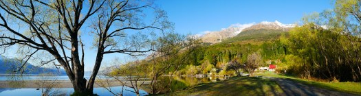
Witness the beauty of dawn at Kinloch, located at the head of Lake Wakatipu.

Lake Wakatipu, an inland lake in the South Island of New Zealand, is perhaps better known by the name Queenstown, situated on its eastern shore. Kinloch is positioned at the head of the lake to the west, right beside the primary tributary, the Dart River. Access to Kinloch can be obtained by road through the township of Glenorchy.

Kinloch Lodge and camping area in the foreground
Kinloch Lodge with the public DOC camping area in the foreground

Morning and evening views of Lake Wanaka

Roys Bay, Wanaka. Sunset
An early morning springtime view of Lake Wanaka

A springtime morning view of Lake Wanaka.

The Buchanan Mountains from Roys Bay, Lake Wanaka, New Zealand.

A similar view in black and white.

Black Peak in the center is often mistaken for Mt Aspiring.

Pastel sunset glow on Lake Wanaka.

Lake Wanaka’s Roys Bay in the evening. With Black Peak in the distance.

Lake Wanaka from Beacon Point.

Beacon Point is simply a very large and shallow area on Lake Wanaka’s shore. There is a permanent red light hundreds of meters from the point to warn boaties.

Glendhu Bay, Lake Wanaka.

Glendhu Bay is a short drive west from Wānaka, Otago, New Zealand. It is on the road to Treble Cone ski field and Mount Aspiring National Park. The bay has a motor camp that is popular with New Zealand locals over the New Year holiday period. Patronage numbers in the many thousands.

Buchanan Mountain Range, from Wanaka

Mt Aspiring National Park

Waterfall, Mount Aspiring National Park, Rob Roy Glacier
Rob Roy Glacier walk, and waterfall

Waterfall and Beech Forest on the Rob Roy Glacier Walk New Zealand. B&W

The walk starts at the Raspberry Creek car park, 54 km west of Wanaka. After about 15 minutes it enters Mount Aspiring National Park. It is an easy 3-4 hours.

Moke Lake, Queenstown

Moke Lake, Queenstown, New Zealand

Dawn. Moke Lake is a small lake just a 15 minute drive from Queenstown, in the South Island of New Zealand.

There is a Dept. of Conservation camping area on the northern shores. And the short Moke Lake Loop Track is popular with walkers and cyclists.

error: Content is protected !!