
Subscribe to continue reading
Subscribe to get access to the rest of this post and other subscriber-only content.
Tēnā koutou from Wānaka Aotearoa NZ
Photos of the South Island of New Zealand – the quest being a landscape re-imagined and then re-imaged

Subscribe to get access to the rest of this post and other subscriber-only content.


Sheep cross the Greenstone River, located a few kilometers down the (gravel) road from Kinloch, beside the lake.
The bridge serves as an access point to the popular Greenstone Caples round-trip tramping track, offering a moderate and relaxing 3-4 day hike.

Capturing the above image while crossing required two things from us:
(It was mind boggling watching about 2000 of them cross a bridge in an orderly manner. A tribute to the stock men and woman that pulled it off with total respect for the animal’s welfare).
As good Kiwi blokes, when we asked if we could hang around and take a photo, the farmer kindly offered us the best advice on where to be. We understood the importance of being considerate (and carrying venison home signaled they were of similar ilk, as it’s a cherished tradition in New Zealand).

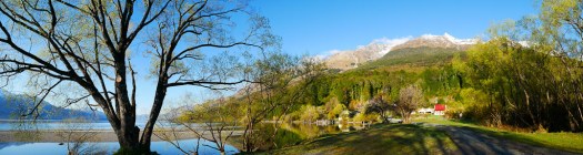
Lake Wakatipu, an inland lake in the South Island of New Zealand, is perhaps better known by the name Queenstown, situated on its eastern shore. Kinloch is positioned at the head of the lake to the west, right beside the primary tributary, the Dart River. Access to Kinloch can be obtained by road through the township of Glenorchy.


A moonlight shot looking towards Mt Aspiring National Park in the distance. The snowy peak being Mt Avalanche. To the right and in dead center, are the lights of Wanaka, with the Buchanan Mountain Range as a backdrop.

Upper Clutha River near Albert Town Wanaka. California Poppies in December are a delight!

The Cardrona, Hawea, Makarora and Matukituki rivers all feed into the Clutha Mata-Au (formerly Molyneaux). The longest river in the South Island of New Zealand. Wanaka airport is to the left, and Wanaka township, out of sight to the right.

Tangential winter lighting reveals the ancient fluvial processes associated with rivers and streams. And now overlaid by relentless Europeanisation in the name of agriculture.

Paddling the Cromwell Gorge, Clutha River, New Zealand. Circa 1985.
This wild river was no more when Lake Dunstan was formed, beginning in April 1992. It is a man-made lake and reservoir and was formed on the Clutha River as a result of the construction of the Clyde Dam.


Gemstone Beach Southland New Zealand.
Gemstone Beach is part of Te Waewae Bay, and near Tuatapere and Orepuki
Semi-precious stones such as garnet, jasper, quartz and nephrite can often be found on the beach. Subject to change of the surface. Sand to stones and back again occurs with the storms and tides of this very wild coast line. The very best of the Southern Coastline!

Wind swept trees on farmland, near Tuatapere, Southland, New Zealand
Tuatapere is on the edge of Fiordland National Park’s wilderness. There is spectacular unspoilt scenery merging with lush rolling farmland. It is an ideal base for many wilderness activities such as tramping, fishing, whitebaiting, hunting and jet boating.
The Waiau River flows through the town before reaching Te Waewae Bay, where Hector’s dolphins and whales are often seen. There is a rich sawmilling history and the area is home to a logging museum, along with many other quaint reminders of the town’s pioneering history.

Cosy Nook Beach Southland New Zealand.
Cosy Nook is on the coastal road between Invercargill and Tuatapere, close to Colac Bay, Gemstone Beach and Monkey Island. And part of part of Te Waewae Bay
It is a picturesque rocky cove sheltering several fishing boats and holiday cribs and baches. It is an important cultural and historical Maori settlement site.
Pahi, as it was originally named after Ngai Tahu Chief Pahi, boasted one of the oldest and largest Maori villages in coastal Murihiku in the 1820s. Captain George Thomson, Harbourmaster of Bluff, named his property Cozy Neuk, after his homeland Scottish village. He was the first European settler.

One of the goals of Photo Quest NZ is draw attention to our unique New Zealand landscape in such a way as to do something tangible towards not only protecting it, but ensuring people grasp the need for habitat restoration for our native species.

Along the way though we leave footprints – not so much in the way of the obvious nasty chemicals used to make images pre digital, but in more subtle and insidious ways such as the need for electronics (with planned obsolescence, not to mention packaging), batteries and data storage.
With these thoughts in mind, and already being off the grid (all Photo Quest studio work is done via solar power) with equipment chosen for it’s potential longevity (can you believe a ten year old iPhone) thoughts recently have gravitated towards travel – the simple act of getting to remote locations and back again.

At least I have accomodation with meIt’s been a habit in the past to go to a new locations, take a few images and then retreat back to the office where they’re evaluated pending another trip to said location. The thought being to be there for sunsets and sunrises, or a snow storm or two.
However recently good friends invited me to have a day trip up Isthmus Peak – a viewpoint popular with young back packers, which gives great panorama views of both Lakes Wanaka and Hawea.

View from the lower section of the Isthmus Peak track
Mts Castor and Pollux from near the top of Isthmus Peak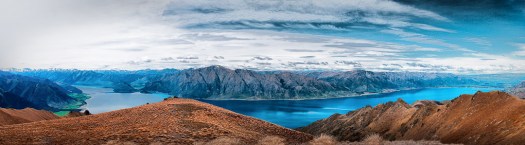
Lake Hawea on the left, Wanaka on the right, from near the top of Isthmus Peak
Lake Hawea on the left, Wanaka on the right
Near the top
Looking across Lake Wanaka we could see the Wilken Valley peaks such as Mount Aeolus, but unfortunately the noon light did not make for a photo equal to the majesty of this viewOn seeing the panoramas offered by this walk, it can come to mind to return for the golden hour after the sun has set, or better yet in this case, be there for dawn. Which actually means burning more fuel.

So one way to improve the light photographically is to use post production software, thus getting a competent image on one visit which goes someway towards sustainable photography. The dull image immediately above was the basis for this oneNone of these blog page images are listed in our shop. Nor are they likely to be. But if you’re interested in purchasing, please note which image and email Donald so I can advise you with a price and options.